Storm Charles Brings Heavy Rain and Strong Winds to Spain and Portugal
Storm Charles is expected to bring severe weather to the Iberian Peninsula this week.
KEY POINTS
- Storm Charles is the third named storm of the 2026/2027 season.
- Red alerts are active in northern Cáceres and southern Ávila, Spain.
- Rainfall may exceed 100 mm in 12 hours in parts of Madeira.
- Wind gusts could reach 130 km/h in elevated areas.
- The storm center may approach via the Gulf of Cádiz or between Sines and Cabo Carvoeiro.
Storm Charles, a subtropical system, is approaching the Iberian Peninsula after Storm Bruna. It is the third named storm of the 2026/2027 season in the southwest European meteorological group. The storm follows Adam and Bruna, which have caused heavy rain and strong winds in Spain since Saturday.
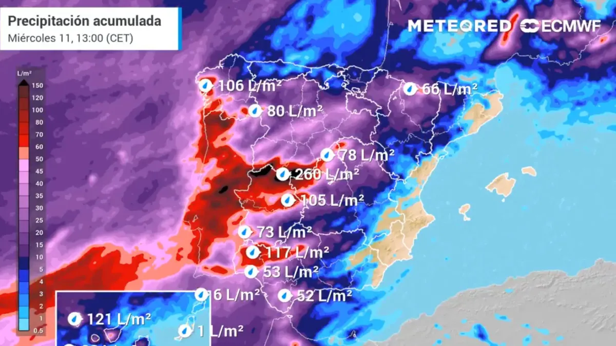
In Spain, the State Meteorological Agency (Aemet) forecasts very adverse weather on Wednesday, with lesser intensity on Thursday. The agency warns of heavy rain, strong winds, and poor sea conditions. Red alerts have been activated in northern Cáceres and southern Ávila for Tuesday from 09:00 to 23:59.
“Charles is a subtropical origin system that will cause a very adverse weather episode of rain, winds and poor sea state on Wednesday and, to a lesser extent, on Thursday.”
In Portugal, the Portuguese Institute for the Sea and Atmosphere (IPMA) expects conditions to worsen in Madeira from late Tuesday and on the mainland on Wednesday. Orange-level warnings are in place. Rainfall exceeding 100 mm within 12 hours is expected in some mountainous areas.
Wind gusts are forecast to reach between 80 and 100 km/h, with peaks around 130 km/h in higher areas. On the mainland, gusts of 100 to 120 km/h are expected from Wednesday afternoon. Wave heights of 3.5 to 4.5 meters are predicted on the south coast of Madeira.
The storm's initial path is expected to pass between the north of the Canary Islands and the Madeira archipelago. The subsequent route remains uncertain, but current data suggests the center may approach the Iberian Peninsula via the Gulf of Cádiz or between Sines and Cabo Carvoeiro.
5 more sources below
COMMENTS (0)
No comments yet. Be the first.
RELATED STORIES

NTSB Recovers Voice Recorder From Fatal Florida Learjet Crash
Investigators retrieved the cockpit voice recorder from the Nov. 1 crash that killed all nine people aboard.

Turkey steel plant blast death toll rises to 17 after crane collapse
An overhead crane fell into a furnace at the HABAS steel factory in Aliaga, killing 17 people and injuring 13.

CHP Pendik district chairman seriously injured in Istanbul traffic crash
Abidin Ekren was rescued from his overturned car and taken to Pendik Training and Research Hospital.
- Mexico's National Seismological Service monitors daily earthquakes across five tectonic plates
- Russia intensifies strikes on Ukraine energy grid ahead of peace talks
- Mother Delivers Baby in Ambulance on Highway 5
- Explosion at HABAŞ Factory in Aliağa Injures Dozens of Workers
- WMO warns 2026 among four hottest years on record
This page was compiled with AI assistance from the outlets named above and passed an automated language check before publication. Montegre has no reporters of its own; the byline names the outlets the story was compiled from. Method and editorial standards