Tropical Storm Vance weakens to Category 1 off Mexico's Pacific coast
Tropical Storm Vance remains off Mexico's Pacific coast, bringing heavy rain and strong winds to several western and southern states.
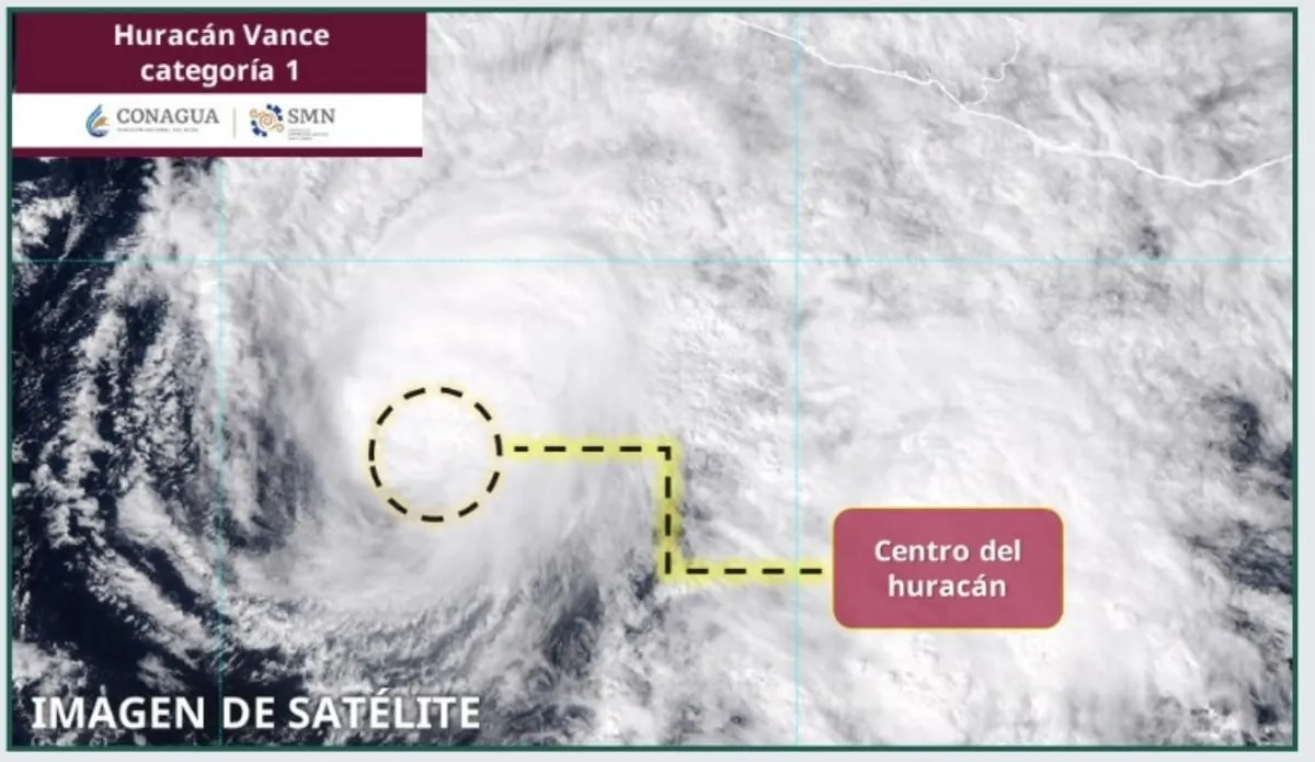
KEY POINTS
- Vance weakened to Category 1 on Saturday, October 24
- Maximum sustained winds reached 148 kilometers per hour with gusts up to 185 kilometers per hour
- Heavy rain of 25 to 50 millimeters was forecast for Jalisco, Colima, Guerrero, and Michoacán
- By Monday, the storm was 445 kilometers south-southwest of Manzanillo
- Low-pressure systems brought rain to much of Mexico, including the Yucatán Peninsula
Tropical Storm Vance weakened to Category 1 on the Saffir-Simpson scale on Saturday afternoon, October 24, according to Mexico's National Meteorological Service. The storm continued to move over the Pacific Ocean at nine kilometers per hour toward the north-northwest.
At 4:00 p.m., the Navy Secretariat reported that Vance was located 530 kilometers south-southwest of Lázaro Cárdenas, Michoacán, and 649 kilometers south of Manzanillo, Colima. Maximum sustained winds reached 148 kilometers per hour, with gusts up to 185 kilometers per hour.
“Its circulation reinforces the probability of showers and heavy localized rain in the western and southern states of Mexico, in addition to strong winds and elevated waves on the coasts of Guerrero and Michoacán.”
The National Meteorological Service forecast heavy rainfall of 25 to 50 millimeters in Jalisco, Colima, Guerrero, and Michoacán. Scattered showers of 5 to 25 millimeters were expected in Oaxaca, while coastal waves of three to four meters were predicted along the shores of Michoacán and Guerrero.
By Monday, October 26, the storm had moved to 445 kilometers south-southwest of Manzanillo, off the coasts of Colima and Jalisco. Its circulation continued to raise the likelihood of heavy to very heavy rainfall in Michoacán, Colima, Jalisco, and Nayarit.
Low-pressure channels and moisture from the Pacific Ocean, the Gulf of Mexico, and the Caribbean Sea also produced showers and heavy rain across northern, northeastern, central, eastern, southern, and southeastern Mexico, including the Yucatán Peninsula. Isolated rainfall was forecast for Mexico City, Morelos, and Tlaxcala.
Authorities warned the population about strong rains in northern states such as Chihuahua, Coahuila, Zacatecas, Durango, Sinaloa, Nayarit, Jalisco, Colima, Michoacán, and Guerrero for that night and the early hours of Tuesday.
2 more sources below
COMMENTS (0)
No comments yet. Be the first.
RELATED STORIES

Stormy weather hits Cyclades and mainland Greece on October 27
Rain, thunderstorms, hail, snow, and strong winds are forecast across Greece on Tuesday, October 27, 2026.

Greenhouse gas concentrations hit record high in 2025, WMO says
The World Meteorological Organization reports atmospheric CO2, methane, and nitrous oxide reached unprecedented levels last year.

Engineers warn unplanned urbanization turned heavy rain into disaster
Chamber of Civil Engineers says record rainfall in Sakarya, Kocaeli and Istanbul exposed unsafe infrastructure and illegal construction.
- Heavy Rain Floods Istanbul's Asian Side, D-100 Partially Closed
- Greece puts nine regions on Red Code weather alert through Thursday
- Cyclone Arnab to strike Andhra Pradesh coast on October 28
- EF2 tornado damages homes and school in central Chile
- Whirlwind destroys two containers at Antalya construction site, killing five workers
This page was compiled with AI assistance from the outlets named above and passed an automated language check before publication. Montegre has no reporters of its own; the byline names the outlets the story was compiled from. Method and editorial standards